A new transit term is coming: linearity.
Linearity refers to how straight transit routes are. A highly linear route is a straight line. A convoluted route is not linear at all.
In dense urban areas, shops and schools, housing and parks are all clustered together. Here a highly linear route can serve many of the places we want to go. However, in suburban areas these are scattered around. This means that reaching important destinations requires travelling on several roads. Transit riders here may be lucky enough to have a route that takes us there, but often we have to transfer or walk.
When designing routes, linearity is easier for drivers and quicker for riders. It makes transit maps look straighter at small scales. It is reminiscent of the days when routes were simply named by the street they travelled along.
Like so many transit concepts, linearity is best applied to the theoretical intersection of land use and transit planning. Furthermore, linearity needs to be balanced with other issues.
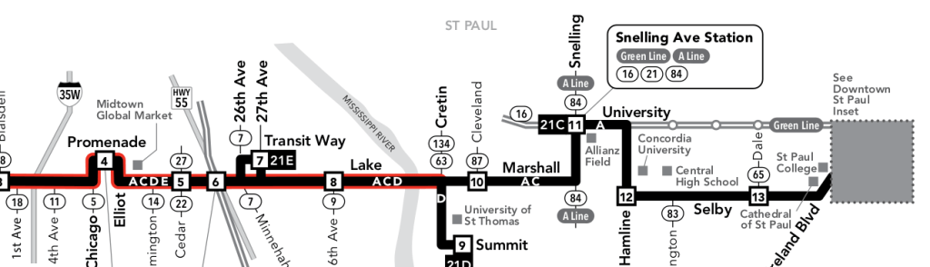
This is Metro Line #21. It has good ridership. But, looking at a map, you can quickly see that it is not linear. Between Marshall Avenue and Selby Avenue, it travels on Snelling, University, and Hamline.
A recent opinion in the MinnPost suggests that this lack of linearity hampers the route’s success:
When the Selby/Lake line connected the two cities over the Lake/Marshall bridge, the key to the streetcar’s success was its straight shot.
The author proposes that the #21 could return to the streetcar alignment. It would once again be the Selby/Lake route, defined by its two main thoroughfares.
However, several things have changed since the days of the local Minneapolis streetcar.
- Fast, frequent light rail serves University Avenue between Minneapolis and Saint Paul.
- Activity centers have grown up along University Avenue.
- The #21 services serves shops and connects with the Green Line at Snelling Avenue Station.
Ridership is so good that Metro Transit in Minneapolis is considering replacing the #21 with a Bus Rapid Transit line. This is the proposed B-Line. It could be not only straighter, and more linear, but also more legible.
The question facing Smith and agency planners is whether the new B Line should follow its current complicated route, jogging north over I-94, or whether it should take a simpler and more legible course to downtown St. Paul.
Linearity means that it is easier to conceive in the imagination. It is more legible and less complicated. For riders new to an area, with no clear destination, legible routes feel more like roads than transit. So, how did the Selby/Lake streetcar become the #21 bus with its University service?
In 1993, a central bridge on Selby Avenue over Ayd Mill Road was replaced, and the No. 21 was detoured north during the construction to jog up to University Avenue.
When considering these issues, a transit planner will also consider:
- Network issues including connections with other routes.
- Destination issues, including access to shops.
- Total trip time, including faster trips made possible by connecting to light rail.
All of these issues argue for another look at the University service on the #21.
So, who is transit for?
Today, the #21 is serving short trips to shops on University. It also serves those headed to work, who connect to Green Line light rail trains at Snelling Avenue Station for a quick trip downtown. All of that requires the service on University:
There it skirted the strip malls and stores on the other side of I-94, ridership spiked with the new detour, and so even after the bridge was replaced, the agency left the odd detour in place.
Ridership spiked!
Although, if linearity is an essential aspect of legibility, then the service on University is an “odd detour” that simply serves “strip malls and stores” on the “other side of I-94.”
The route became more useful to more people. They rode it more often. The route became so successful that it is now being considered for Bus Rapid Transit. At that point, the route became a map, a colored line on a planners desk.
If transit is for riders, then access to shops, even strip malls, is important.
Many of the planners mentioned in this article understand the need to connect people to destinations, but are then distinguish by highlighting a single attribute of transit.
From streetcar to BRT: The return of the Selby-Lake transit corridor?
One last comment, for those who noticed the reference to strip malls on the other side of the highway. The Shelby/Lake streetcar line served a different economic strata as well:
Unlike the other inter-city streetcars, the Selby-Lake line ran through the fast-growing, wealthier southern reaches of the city…

I appreciate the discussion on the pros/cons of linearity. I might add a little.
Every transit agency has service standards. Usually, the bigger the agency, the more elaborate the standards. I have seen larger agencies that have standards for linearity. For example, you could measure the crow-flies miles over the route miles. A route that is perfectly straight will have 10 crow-flies miles and 10 route miles, to be 100% straight. A route that has 10 route miles, but is only 8 miles as-the-crow-flies is only 80% straight.
Quantifying linearity it is one thing. The question is why? The problem with standards like these is they correctly realize that–all other things being equal–people would rather have a fast, direct trip, but then falsely act as if all other things are in fact equal.
In reality, they never are. And quantifying the tradeoffs is not simple. When you make the route more direct, you may miss a lot of riders on some minor street, or force a transfer. How do you weigh that? The engineers will always be able to answer this with another formula or equation. But in my experience, this is around the point where we’ve departed from practicality.
There’s an even bigger problem with overengineering route design around equations like these. These are all equations that attempt–accurately or not–to quantify the attractiveness of a route. But that is seldom the most important part of route design.
Non-practitioners tend to think route design is all about “figuring out where you’d get the most riders.” Researchers will often develop (and consultants will market) what they assume is some kind of master, universal, composite index for transit demand, based on all the key variables, and declare the problem solved. But they are only looking at half the ledger–the demand side. And it is the less important side.
The reality of route design is that the cost side is where a route designer has more room to work. Think about it. In America, farebox recovery is usually only about 20 percent. Why focus on something that is ultimately speculative, that takes time to ramp up, and that ultimately will account for only 20 percent of your budget? The cost side of the ledger is knowable, controllable, amenable to good design, and the effects of changes are essentially immediate.
Outside of transit agencies, and a few specialty consultants, there is very little grasp that transit operating costs are subject to enormous step costs. If you are serving a neighborhood today with five buses, and through improved network design, are able to serve all the same key points with just four buses, you just saved 20 percent. That is the financial equivalent of the entirety of your ridership. Those resources are now available to do other good things.
LikeLike